Six people were buried in a landslide on Mt. Maunganui during heavy rain last Thursday. As the country deals with the aftermath, it is time to look at what contribution land use planning may have made to the event.
Following the Auckland Anniversary flood event there were several concerns raised about the development of high risk landslide zones.
One stemmed from significant flood incidents inside the wider Auckland flood emergency, where sloped terrain that had value for people wanting of altitude or a view, had given way under sustained rain. The sudden input of the sediment from the landslip into the catchment then caused secondary flooding that compounded the problem.
A second was the removal of critical vegetation for land development. In the case of Auckland, which has numerous hills of volcanic origin, natural water courses rerouted by lava flows, have been built over often with little concern for soil retention and stability.
A third was the actual development of land in high risk flood zones. These might be confluence areas where the confluence/s of waterways exists, or around ponding areas where water collects either by design or for lack of a natural course to lower altitude.
A fourth, which may not have been raised, but really should be, is how the coverage of terrain in urban areas prevents absorption of rainwater by the ground. This leads to accelerated run off, which during very high precipitation rainfall events, is the cause of flash flooding from a volume of water that is simply too great for the known drainage to cope with.
Fast forward three years to Tauranga in January 2026. The city is soggy after days of rain. School holidays are still going and there are a lot of tourists in the city trying to make the most of their time despite the increasingly bad weather.
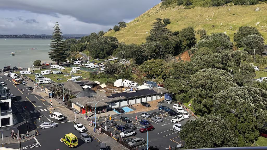
Mt. Maunganui is an old rhyolite lava dome that was extruded about 3 million years ago. It is a very popular walking spot with many people every day walking up to the summit, and creating one of New Zealand’s most iconic backdrops. Land use planning and urban development has seen residential development across the tombolo, all the way to the foot. Given that warning calls were made to the 111 line warning that minor land sliding was happening and the possibility of a bigger damaging one was very real nearly 4 hours before the main event. Below, in the same order that I addressed my concerns as they related to the Auckland floods, I address the Tauranga event below:
First, when one looks at Mt. Maunganui and its surrounds, it is not difficult to see why people have built up to the lower foot. A small rise in elevation increases the aesthetic value of properties considerably. From a motor camp perspective, so close to beaches on one side, a yacht harbour on the other and shops just a few hundred metres away. Planners may have believed that the Mt. being of volcanic origin was strong in soil and rock composition, and thus not prone to rock or landslides except in extreme events.
Second, as Mt. Maunganui is at the end of a tombolo (sand spit) only a few hundred metres wide, this is somewhat of a lesser concern with the harbour to the left and Bay of Plenty to the right. Natural drainage would discharge most water. The bigger concern would be overflow, which in a high precipitation/high intensity event, particularly where the soil is saturated and has little bearing strength, the landslide risk increases markedly.
Third, people have noted the removal of specific vegetation that might have been essential in restraining the sediment from around the very lower slopes of Mt. Maunganui. While this might have contributed to the landslide, the dome has been in place for 3 million years, and has accumulated significant loess (wind blown sediment) in that time. The volcanic structure has been exposed to erosive processes and is not the same strongly bonded rhyolitic edifice that was initially emplaced. On such steep slopes, some landsliding is inevitable.
Fourth, the run off from the Mt. may have been compounded by the filling in of any natural drainage in the camping ground. This, however is not likely to have contributed to the landslide last week, which most likely stemmed from saturated soil losing its cohesion and the overlying vegetation being insufficient to hold it in place.
In 2024 the National led Government abolished the $6 billion National Resilience Fund and others that might have contributed to a less dangerous landslide environment around New Zealand.. The justification was that too many different funds were diverting the money away. How much of it has been spent on relevant projects, is unknown.
The camping ground landslide is far from the only one to have happened on Mt. Maunganui. It is simply the most recent. High resolution imagery shows another two older landslide scars directly behind the campground, and quite close to last weeks event.
More landslide events will happen in the future. Will New Zealand learn from Tauranga, and take steps to reduce the impact of the next event? Will agencies learn to simply pass on the message as the call centre at Tauranga City Council appears to not have done?
Or will the next one result in premature funerals like Thursday’s event did?
